Earlier this year, I described how to create and pan-sharpen a multi-spectral 3-band composite Landsat-8 raster. Although I’m all for using free satellite imagery, sometimes it isn’t enough and you need to buy high-resolution satellite imagery from a suitable provider. Such was the case for my work on the archival material from Hogarth’s excavations in the necropolis of Gebel Asyut el-Gharbi in 1906-7. As part of the project, we were able to purchase some high-resolution Worldview-3 satellite imagery of the site, and a 2m digital surface model (DSM), generated from stereo-pair Worldview-2 images. In order to make the best use of these remotely-sensed data, I needed to process the satellite imagery to create a pan-sharpened and orthorectified image as a base map for my research.
Satellite imagery – what you get
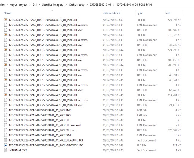
In order to understand why I needed to process the satellite imagery, we need to dig into what it comprises and how it’s delivered to the user. The precise nature of satellite imagery varies somewhat depending on which sensor it comes from, who you obtained it from, whether you paid for it, and what level of processing was already applied when you received it. I received the Worldview-3 satellite ‘ortho-ready’, meaning that it was prepared for me to pan-sharpen and orthorectify it. Each satellite image comprised two folders both named by the same numeric code, one filename ending ‘_MUL’ and one filename ending ‘_PAN’. The MUL folder contains the multi-spectral bands and the PAN folder contains the higher-resolution panchromatic band.

Each folder contains a series of .tif tiles, each of which covers part of the area purchased, while the .TIL file, covers the entire area occupied by those .tifs in a single raster file. There are also .IMD files, .RPB files, .XML files, and several .txt files with additional information in each folder.


Pan-sharpening
As with the Landsat-8 data, the Worldview-3 multispectral bands are lower (c.1.3m) resolution than the panchromatic band (c.0.3m) and need to be pan-sharpened to create a 0.3m resolution multispectral image. Because the Worldview-3 data is provided as a series of .tifs, it’s necessary to pan-sharpen each of the multispectral .tif files separately using the equivalent panchromatic .tif file. Once all the .tif files have been pan-sharpened I will mosaic them into a new raster.
As with the Landsat-8 imagery, I pan-sharpened all the .tif files using the ‘Create Pansharpened Raster Dataset‘ tool of the Data Management>Raster>Raster processing toolset of ArcGIS ArcTools. I used the Gram-Schmitt method, as it allowed me to automatically weight the bands by choosing ‘Worldview-3’ under ‘Sensor’. Although it’s also possible to pan-sharpen using Symbology tab of the layer’s properties and in the Image Analysis Window I chose to use the ‘Create Pansharpened Raster Dataset’ tool because it allows me to specify which bands should be included in the resulting raster rather than relying on the progamme (as happens in the Image Analysis Window).


You can watch of video of me pan-sharpening the Worldview-3 imagery here or on my Youtube channel.
The resulting pan-sharpened tif files were of much higher resolution than the original multispectral data. The following shows the pan-sharpened Worldview-3 data compared to the pan-sharpened Landsat-8 data I generated in a previous post. The difference in resolution is very clear.


Acknowledgements
All the images in this blog post were created using ArcGIS® software by Esri. ArcGIS® and ArcMap™ are the intellectual property of Esri and are used herein under license. Copyright © Esri. All rights reserved. For more information about Esri® software, please visit http://www.esri.com.
Worldview-3 imagery © 2018 DigitalGlobe Inc. supplied by European Space Imaging. Landsat 8 data from the United States Geological Survey.
Find out more
Related posts
-

Pan-sharpening a Worldview-3 satellite imagery of Gebel Asyut el-Gharbi
-

Mosaicking pan-sharpened Worldview-3 satellite imagery of Gebel Asyut el-Gharbi


Pingback: Mosaicking pan-sharpened Worldview-3 satellite imagery of Gebel Asyut el-Gharbi – Scribe in the House of Life: Hannah Pethen Ph.D.
Pingback: Orthorectifying Worldview-3 satellite imagery of Gebel Asyut el-Gharbi – Scribe in the House of Life: Hannah Pethen Ph.D.